Asia

ဖိလစ်ပိုင်နိုင်ငံ တောင်ပိုင်းတွင် တိုင်ဖွန်းမုန်တိုင်း ရိုင် ဝင်ရောက်တိုက်ခတ်
မနီလာ၊ ဒီဇင်ဘာ ၁၇ ရက် (ဆင်ဟွာ)
ဖိလစ်ပိုင်နိုင်ငံအတွင်း ယခုနှစ်၏ အားအကောင်းဆုံး မုန်တိုင်းတစ်ခုဖြစ်သော တိုင်ဖွန်းမုန်တိုင်း ရိုင် (Rai) သည် နိုင်ငံတောင်ပိုင်း Siargao ကျွန်းသို့ ဒီဇင်ဘာ ၁၆ ရက် မွန်းလွဲပိုင်းက ဝင်ရောက်တိုက်ခတ်ခဲ့ကြောင်း ဖိလစ်ပိုင် မိုးလေဝသဗျူရိုက ပြောကြားခဲ့သည်။
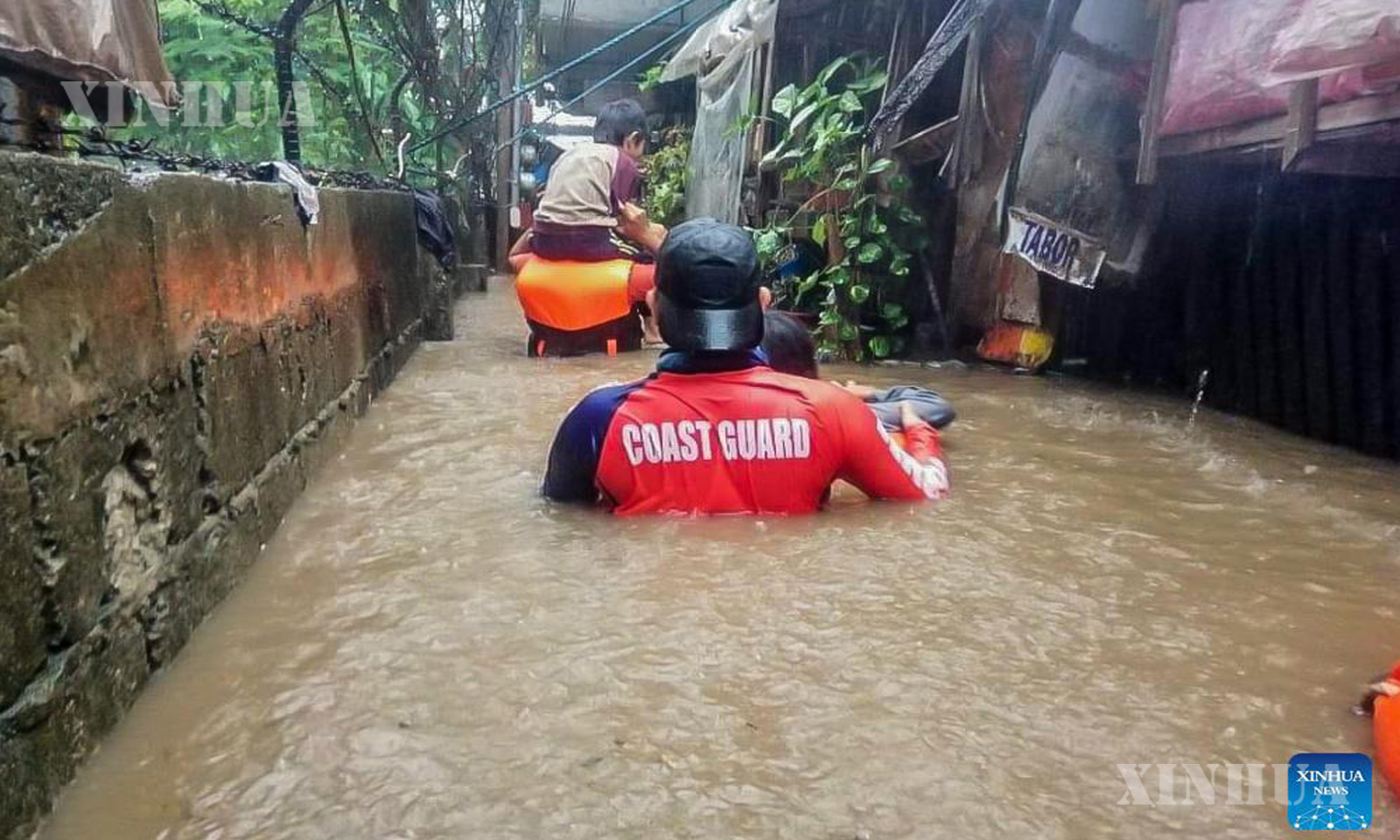
ဖိလစ်ပိုင်နိုင်ငံ Cagayan de Oro မြို့တွင် တိုင်ဖွန်းမုန်တိုင်း ရိုင်ကြောင့် ရေလွှမ်းမိုးမှုဖြစ်ပွားခဲ့ရာ ဒေသခံများအား ဖိလစ်ပိုင် ကမ်းခြေစောင့်တပ်ဖွဲ့ဝင်များက ကယ်ဆယ်နေသည်ကို ဒီဇင်ဘာ ၁၆ ရက်က တွေ့ရစဉ် (ဆင်ဟွာ)

ဖိလစ်ပိုင်နိုင်ငံ Cagayan de Oro မြို့တွင် တိုင်ဖွန်းမုန်တိုင်း ရိုင်ကြောင့် ရေလွှမ်းမိုးမှုဖြစ်ပွားခဲ့ရာ ဒေသခံများအား ဖိလစ်ပိုင် ကမ်းခြေစောင့်တပ်ဖွဲ့ဝင်များက ကယ်ဆယ်နေသည်ကို ဒီဇင်ဘာ ၁၆ ရက်က တွေ့ရစဉ် (ဆင်ဟွာ)
မုန်တိုင်းလမ်းကြောင်းတစ်လျှောက်ရှိ ဒေသခံထောင်ပေါင်းများစွာအား ဘေးလွတ်ရာသို့ ရွှေ့ပြောင်းခဲ့ရကြောင်း သိရသည်။
အဆိုပါ မုန်တိုင်းသည် ကျွန်းအတွင်းသို့ ဒေသစံတော်ချိန် မွန်းလွဲ ၁:၃၀ နာရီ၌ လေတိုက်နှုန်း အများဆုံး တစ်နာရီလျှင် ၁၉၅ ကီလိုမီတာနှင့် လေပြင်းတိုက်ခတ်မှုမှာ တစ်နာရီလျှင် ၂၄၀ ကီလိုမီတာအထိ တိုက်ခတ်လျက် Surigao del Norte ပြည်နယ်ရှိ Siargao ကျွန်းသို့ ချဉ်းကပ်ဝင်ရောက်လာခဲ့သဖြင့် နောက်ထပ်ပြင်းထန်ခဲ့ခြင်း ဖြစ်ကြောင်း ဖိလစ်ပိုင် လေထု၊ ဘူမိရူပဗေဒနှင့် နက္ခတ္တဗေဒဆိုင်ရာလုပ်ငန်းဦးစီးဌာနက ပြောကြားခဲ့သည်။
တိုင်ဖွန်းမုန်တိုင်း ရိုင်သည် ပြင်းထန်သောလေတိုက်နှုန်းများဖြင့် တစ်နာရီလျှင် ကီလိုမီတာ ၃၀ နှုန်းဖြင့် အနောက်မြောက်ဘက်သို့ တိုက်ခတ်လျက်ရှိပြီး လမ်းကြောင်းကျသော ဒေသများစွာ၌ မိုးသည်းထန်မှုများ ဖြစ်ပေါ်စေခဲ့သည်။
အဆိုပါ တိုင်ဖွန်းမုန်တိုင်း ရိုင်သည် အနောက် အနောက်မြောက်ဘက်သို့ ရွှေ့လျားပြီး သောကြာနေ့ (ဒီဇင်ဘာ ၁၇ ရက်) နံနက်ပိုင်းတွင် စူးလူးပင်လယ်အတွင်း၌ မပေါ်ထွက်မီ ဖိလစ်ပိုင်နိုင်ငံ အလယ်ပိုင်းဒေသရှိ ပြည်နယ်များစွာအား ဖြတ်သန်းသွားမည်ဟု ခန့်မှန်းထားသည်။ ယင်းမုန်တိုင်းသည် သောကြာနေ့ မွန်းလွဲပိုင်း သို့မဟုတ် ညနေပိုင်း၌ Palawan ပြည်နယ် မြောက်ပိုင်း သို့မဟုတ် အလယ်ပိုင်းအား ဖြတ်သန်းသွားမည်ဟု ခန့်မှန်းထားကြောင်း သိရသည်။
ကမ်းရိုးတန်းကျေးရွာများ အပါအဝင် ဖိလစ်ပိုင်နိုင်ငံ အလယ်ပိုင်းနှင့် မြောက်ပိုင်း မင်ဒါနာအိုကျွန်းရှိ ပြည်သူ ၄၅,၀၀၀ ကျော်အား ရေလွှမ်းမိုးမှုနှင့် မုန်တိုင်းဒဏ်မှ လွတ်မြောက်ရန် ဘေးလွတ်ရာသို့ ရွှေ့ပြောင်းခဲ့ရကြောင်း အမျိုးသား သဘာဝဘေးအန္တရာယ် လျှော့ချရေးနှင့် စီမံခန့်ခွဲမှုကောင်စီက ပြောကြားခဲ့သည်။
တိုင်ဖွန်းမုန်တိုင်းကြောင့် ဖိလစ်ပိုင်နိုင်ငံ အလယ်ပိုင်း၊ Bicol ဒေသနှင့် အရှေ့မြောက်ပိုင်းရှိ မင်ဒါနာအို တို့တွင် ပြည်သူ ၄,၀၀၀ နီးပါး၊ ရွက်လွှင့်နေသော ကုန်တင်သင်္ဘော ၁,၈၀၀ နီးပါးနှင့် သင်္ဘော ၈၀ စင်းတို့ သောင်တင်နေခဲ့ကြောင်း ဖိလစ်ပိုင် ကမ်းခြေစောင့်တပ်ဖွဲ့ (PCG) က ပြောခဲ့သည်။
Eastern Samar ပြည်နယ် အုပ်ချုပ်ရေးမှူး Ben Evardone က မြို့ပေါင်း ၂၃ မြို့အနက် ၂၁ မြို့မှ ဒေသခံ ၃၀,၀၀၀ နီးပါးအား ဘေးလွတ်ရာသို့ ရွှေ့ပြောင်းခဲ့ရကြောင်း ပြောကြားခဲ့သည်။
“အထူးသဖြင့် ပြည်နယ်တောင်ပိုင်းမှာ မိုးသည်းထန်မှုနဲ့ လေပြင်းတိုက်ခတ်မှုတွေကို ခံစားခဲ့ရပြီးဖြစ်ပါတယ်” ဟု ၎င်းက ဆိုသည်။
ပစိဖိတ် မီးကွင်း (Pacific Ring of Fire) ဟုခေါ်ဆိုသော နေရာ၌ တည်ရှိသော ဖိလစ်ပိုင်နိုင်ငံသည် ဘေးအန္တရာယ် အမြောက်အများ ထိခိုက်ခံစားခဲ့ရသည်။ ဖိလစ်ပိုင်နိုင်ငံတွင် ၂၀၁၃ ခုနှစ်က စူပါတိုင်ဖွန်းမုန်တိုင်း ဟိုင်ယန် (Haiyan) နှင့် ၂၀၂၀ ပြည့်နှစ်က Taal မီးတောင်ပေါက်ကွဲခြင်း အပါအဝင် မကြာသေးမီနှစ်များက အဓိက သဘာဝဘေးအန္တရာယ်များစွာ ဖြစ်ပွားခဲ့ကြောင်း သိရသည်။ (Xinhua)
……………………………………….
(English Version)
Typhoon Rai makes landfall in southern Philippines
Source: Xinhua| 2021-12-16 17:01:30|Editor: huaxia
MANILA, Dec. 16 (Xinhua) — Typhoon Rai, one of the strongest battering the Philippines this year, made landfall in Siargao Island in the southern Philippines on Thursday afternoon, the Philippines’ weather bureau said.
Thousands of residents along its path were forced to be evacuated to safety.
The Philippine Atmospheric, Geophysical, and Astronomical Services Administration said Rai intensified further as it approached Siargao in Surigao del Norte province, blowing maximum winds of 195 km per hour and with gusts of up to 240 km per hour when it slammed into the island at 1:30 p.m. local time (0530 GMT).
The bureau said Rai was blowing northwestward at 30 km per hour with “destructive typhoon-force winds” and heavy rains over many regions in its path.
Rai is forecast to move west northwestward and cross several provinces in the central Philippines regions before emerging over the Sulu Sea on Friday morning. It is forecast to cross the northern or central Palawan province on Friday afternoon or evening.
The National Disaster Risk Reduction and Management Council said more than 45,000 people in the central Philippines and northern Mindanao, including coastal villages, had been evacuated to safety due to the threat of flash flood and storm surge.
The Philippine Coast Guard (PCG) said nearly 4,000 people, almost 1,800 rolling cargoes, and more than 80 vessels were stranded in the central Philippines, Bicol Region, and northeastern Mindanao due to the typhoon threat.
Eastern Samar province Governor Ben Evardone said nearly 30,000 residents from 21 of the 23 towns comprising the province had been evacuated.
“We are already feeling the impact of heavy rains and strong winds, especially in the southern part of the province,” he said.
Located in the Pacific Ring of Fire, the Philippines is highly vulnerable to multiple hazards. In recent years, the archipelagic country has been hit by major disasters, including super typhoon Haiyan in 2013 and the Taal volcano eruption in January 2020. Enditem
1- 3-Members of the Philippine Coast Guard rescue residents from the flood brought by typhoon Rai in Cagayan de Oro City, the Philippines, Dec. 16, 2021. Typhoon Rai, one of the strongest battering the Philippines this year, made landfall in Siargao Island in the southern Philippines on Thursday afternoon, the Philippines’ weather bureau said. Thousands of residents along its path were forced to be evacuated to safety. (Philippine Coast Guard/Handout via Xinhua)