
North America
အမေရိကန်နိုင်ငံ အနောက်ပိုင်းရှိ အဓိက ရေကန်များနှင့် မြစ်များတွင် စိုးရိမ်ဖွယ် ရေလယ်ဗယ်လျော့ကျမှုဖြစ်နေ
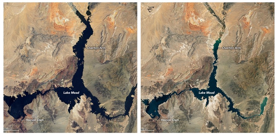
အမေရိကန်နိုင်ငံ အနောက်ပိုင်းရှိ အဓိက ရေကန်များနှင့် မြစ်များတွင် စိုးရိမ်ဖွယ် ရေလယ်ဗယ်လျော့ကျမှုကို ကမ္ဘာမြေအထက် ကီလိုမီတာ ၃၅,၀၀၀ မှ ရိုက်ကူးထားသော နာဆာ ဂြိုဟ်တုဓာတ်ပုံများက ပြသနေပြီး သမိုင်းဝင် “ကြီးမားသော မိုးခေါင်ရေရှားမှု” အဖြစ် မီးမောင်းထိုးဖော်ပြထားသည်။ (Xinhua)
………………………………………………
NASA satellite pictures from 35,000 km above Earth show drastic water levels drop in major lakes and rivers in the U.S. west, highlighting the historic “mega-drought.”
Combo photo taken by NASA satellites shows the water level change between July 6, 2000 (L) and July 3, 2022 in Lake Mead, Nevada, the United States. (Photo credit: NASA Earth Observatory)
Continue Reading