Asia
ဂျပန်နိုင်ငံ အနောက်ပိုင်းတွင် Lupit တိုင်ဖွန်းမုန်တိုင်း ဝင်ရောက်
တိုကျို၊ ဩဂုတ် ၉ ရက် (ဆင်ဟွာ)
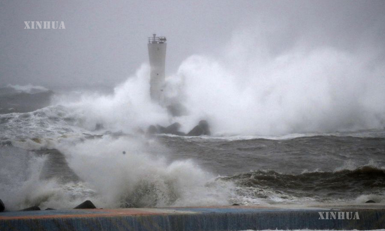
ဂျပန်နိုင်ငံ အနောက်တောင်ပိုင်း Kyushu ဒေသတွင် ဩဂုတ် ၈ ရက် ညပိုင်းက Lupit တိုင်ဖွန်းမုန်တိုင်း ဝင်ရောက်ခဲ့ပြီးနောက် ဩဂုတ် ၉ ရက် နံနက်ပိုင်းက နိုင်ငံအနောက်ပိုင်း၌ လေပြင်းတိုက်ခတ်ခြင်းနှင့် မိုးသည်းထန်စွာ ရွာသွန်းခြင်းများ ဖြစ်ပေါ်ခဲ့ကြောင်း မိုးလေဝသအေဂျင်စီက ပြောကြားခဲ့သည်။ယခုနှစ်၏ ၉ လုံးမြောက်ဖြစ်သည့် Lupit တိုင်ဖွန်းမုန်တိုင်းသည် ဩဂုတ် ၉ ရက် ဒေသစံတော်ချိန် နံနက် ၅ နာရီက ဟီရိုရှီးမားစီရင်စုရှိ Kure မြို့အနီးသို့ ဝင်ရောက်ခဲ့ပြီးနောက် ဂျပန်ပင်လယ်သို့ ရောက်ရှိမည်ဟု ခန့်မှန်းထားကြောင်း၊ ဩဂုတ် ၁၀ ရက်အထိ ဂျပန်နိုင်ငံ အနောက်ပိုင်း၊ အရှေ့ပိုင်းနှင့် မြောက်ပိုင်းဒေသများတွင် မိုးသည်းထန်ခြင်းနှင့် လေပြင်းတိုက်ခတ်ခြင်းများ ဖြစ်ပေါ်နိုင်ကြောင်း ဂျပန် မိုးလေဝသအေဂျင်စီအရ သိရသည်။
ပြည်သူများအနေဖြင့် ရွှံ့နွံပြိုကျခြင်းနှင့် ရေကြီးရေလျှံခြင်းအား သတိရှိကြရန် အကြံပြုထားကြောင်း၊ ဟီရိုရှီးမား၊ ရှီမာနဲ၊ အီဟီမဲနှင့် အိုအီတာ စီရင်စုများရှိ နေရာအချို့တွင် ရွှံ့နွံပြိုကျခြင်းများနှင့် ဟီရိုရှီးမားနှင့် ယာမာဂူချီ စီရင်စုများရှိ မြစ်အချို့တွင်လည်း ရေကြီးရေလျှံမှု သတိပေးအဆင့်များအထက် ရှိကြောင်း သတိပေးထားသည်။
အဆိုပါ မုန်တိုင်းသည် ဩဂုတ် ၁၀ ရက် နံနက်ပိုင်းမှတစ်ဆင့် ၂၄ နာရီအတွင်း ရှိနေမည်ဟု ခန့်မှန်းထားပြီး မိုးသည်းထန်ခြင်းမှာလည်း ဂျပန်နိုင်ငံ အလယ်ပိုင်းရှိ တိုကာအီဒေသ၌ မိုးရေချိန် ၃၀၀ မီလီမီတာအထက် ရောက်ရှိနိုင်မည်ဖြစ်ပြီး ကန်တိုနှင့် ကင်ကိဒေသများအပါအဝင် ကျယ်ပြန့်သောဒေသများ၌ မိုးရေချိန် ၁၀၀ မီလီမီတာနှင့် ၁၈၀ မီလီမီတာကြား ရှိနိုင်ကြောင်း သိရသည်။
အဆိုပါ တိုင်ဖွန်းမုန်တိုင်းသည် ဒေသစံတော်ချိန် နံနက် ၆ နာရီအထိ တော့တိုရီစီရင်စု ယွန်နာဂို တောင်-အနောက်တောင်ဘက် ၇၀ ကီလိုမီတာခန့်အကွာတွင် တစ်နာရီလျှင် ၄၅ ကီလိုမီတာခန့်ဖြင့် အရှေ့မြောက်ဘက်သို့ ရွေးလျားရှိကြောင်း၊ Lupit တိုင်ဖွန်းမုန်တိုင်း၏ လေဖိအားသည် ဗဟိုချက်၌ ၉၈၅ ဟတ်တိုပတ်စ်ရှိခဲ့ကြောင်းနှင့် လေပြင်းတိုက်ခတ်နှုန်းမှာ တစ်နာရီလျှင် ၁၂၆ ကီလိုမီတာအထက် တိုက်ခတ်ခဲ့ကြောင်း သိရသည်။
အဆိုပါ တိုင်ဖွန်းမုန်တိုင်းသည် ဒေသစံတော်ချိန် နံနက် ၆ နာရီအထိ တော့တိုရီစီရင်စု ယွန်နာဂို တောင်-အနောက်တောင်ဘက် ၇၀ ကီလိုမီတာခန့်အကွာတွင် တစ်နာရီလျှင် ၄၅ ကီလိုမီတာခန့်ဖြင့် အရှေ့မြောက်ဘက်သို့ ရွေ့လျားလျက်ရှိကြောင်း၊ Lupit တိုင်ဖွန်းမုန်တိုင်း၏ လေဖိအားသည် ဗဟိုချက်၌ ၉၈၅ ဟတ်တိုပတ်စ်ရှိခဲ့ကြောင်းနှင့် လေပြင်းတိုက်ခတ်နှုန်းမှာ တစ်နာရီလျှင် ၁၂၆ ကီလိုမီတာအအထိ တိုက်ခတ်ခဲ့ကြောင်း သိရသည်။ (Xinhua)
———————————————–
(English Version)
Typhoon Lupit makes landfall on western Japan
TOKYO, Aug. 9 (Xinhua) — Typhoon Lupit pummeled western Japan with strong winds and heavy rain early Monday morning after making landfall on the southwestern Kyushu region Sunday night, the weather agency said.
According to the Japan Meteorological Agency, Typhoon Lupit, the ninth typhoon of the year, is expected to reach the Sea of Japan after making landfall near Kure in Hiroshima Prefecture shortly past 5:00 a.m. local time Monday, while bringing downpours and strong winds to western, eastern and northern Japan areas through Tuesday.
People are recommended to be vigilant against possible mudslides and floods. Mudslide alerts were issued in some parts of Hiroshima, Shimane, Ehime, and Oita prefectures, and some rivers in Hiroshima and Yamaguchi prefectures are above their flood warning levels.
It is expected that in the 24 hours through Tuesday morning, the rainfall will reach up to 300 mm for the Tokai region in central Japan and between 100 mm and 180 mm in wide areas including the Kanto and Kinki regions.
As of 6:00 a.m. local time, the typhoon was moving northeast at around 45 km per hour about 70 km south-southwest of Yonago, Tottori Prefecture. The atmospheric pressure of Typhoon Lupit was 985 hectopascals at its center, and the wind speed was as high as 126 kph. Enditem